
Item 1
OIA 19-E-0696
4 November 2019
s9(2)(a)
Dear s9(2)
Thank you for your Official Information Act request to the Department of
Conservation, dated 4 October 2019. You requested the following:
How many reviews/investigations involving external bodies (ie. law firms, Government
appointees outside DOC) have occurred within the Information Systems and Services Group
(ISS) since January 1 2015. Please state what prompted these reviews/investigations, the
external members appointed to consider the complaints, how long they took to be completed,
and whether any disciplinary action resulted. Please provide the total cost for these
reviews/investigations.
Over the same period, please detail how many personal grievance claims have been made
from ISS staff/former staff, and total payments made as a result of those.
For each financial year, starting from 2014/15, please provide the annual budget of the ISS
group.
PWC is auditing the department’s ICT function. Please provide its terms of reference.
s9(2)(a)
there was a recent review which examined where the
GIS team best fits within corporate services. Please provide all notes/submissions/advice to
the committee considering the GIS move, plus the decision-maker’s written
decision/explanation.
under the Official Information Act
Your questions and our responses are listed below:
1.
How many reviews/investigations involving external bodies (ie. law firms, Government
appointees outside DOC) have occurred within the Information Systems and Services
Group (ISS) since January 1 2015.
From 1 January 2015 to date, there has been one investigation involving an
external body.
Released
2.
Please state what prompted these reviews/investigations, the external members appointed
to consider the complaints, how long they took to be completed, and whether any
disciplinary action resulted.
The investigation was prompted by an allegation of workplace bullying and
harassment.
An investigation team (Greg Cain, a Partner of Kensington Swan and Joanne
Harrison, then the General Manager, Organisational Development and Shared
Services at the Ministry of Transport) was appointed to consider the allegations.
The investigation took approximately eight months to be completed and at its
Act
conclusion, the report found that the allegations were not substantiated.
3.
Please provide the total cost for these reviews/investigations.
The total costs associated with this investigation managed by Kensington Swan is
commercially sensitive information, under section 9(2)(b)(ii) and is withheld.
4.
Over the same period, please detail how many personal grievance claims have been made
from ISS staff/former staff, and total payments made as a result of those.
From 1 January 2015 to date, there have been a total of four personal grievance
Information
claims from staff in the Information Systems and Services (ISS) Unit, all of which
were settled. The total costs of these settlements was $157,447.
5.
For each financial year, starting from 2014/15, please provide the annual budget of the
ISS group.
2013-14 - $15,733,543
Official
2014-15 - $16,605,071
2015-16 - $18,054,507
2016-17 - $20,186,025
the
2017-18 - $24,043,102
2018-19 - $27,433,715
2019-20 - $25,780,895*
* As at 30 June 2019 the staffing structure in ISS was 101 positions. The shift of
the Geospatial Unit has reduced this to 69 positions in the 2019/20 year.
under
6.
PWC is auditing the department’s ICT function. Please provide its terms of reference.
PWC is not auditing the Department’s ICT function. PWC has been engaged to
assist the Department to refresh the Information Systems Strategic Plan 2016-
2019 which is nearing its expiry date.
7. s9(2)(a)
Released
there was a recent review which examined
where the GIS team best fits within corporate services. Please provide all
notes/submissions/advice to the committee considering the GIS move, plus the decision-
makers written decision/explanation.
A recent task assignment issued by the then DDG of Corporate Services Rose
Anne McLeod asked the CIO/Director ISS to determine “…where GIS best fits
within Corporate Services Group to provide synergistic returns to DOC…”.

The following documents fall within the scope of your request and are attached:
Item
Date
Document description
Decision
1.
7 June
Mahi Kotahi Task Assignment –
Released in full
2019
Geospatial Services Team
2.
17 June
GIS Task Assignment - Feedback
Partial release
2019
Act
3.
19 June
Mahi Kotahi for GIS - Feedback
Partial release
2019
4.
26 June
BfoB Feedback
Partial release
2019
5.
19 June
Report to GIS Managers –
Partial release
2019
Analysts’ Thinking on CSG Change
Proposal
6.
26 June
Options for Geospatial Team fit
Partial release
2019
within CSG
7.
6
Geospatial Services Structural Lift
Released in full
September and Shift to Outcomes
Information
2019
Management Office
8.
29 August GIS Realignment to Outcomes
Released in full
2019
Management Office
Documents marked “Partial release” have had the names and/or titles of
Departmental staff and any other information that could lead to the identification of
Official
people redacted - these have been withheld pursuant to section 9(2)(a) of the Act
which protects the privacy of natural persons.
the
In making the decision to withhold information, I have considered the public interest
considerations in section 9(1) of the Official Information Act.
You are entitled to seek a review of my decision by writing to an Ombudsman as
provided by section 28(3) of the Official Information Act.
under
Yours sincerely
Neal Gordon
Director
Outcomes Management
Released
Corporate Services Group

Act
Information
Official
the
under
Released

Item 2
� Department of Conservation
� Te Papa Atawhai
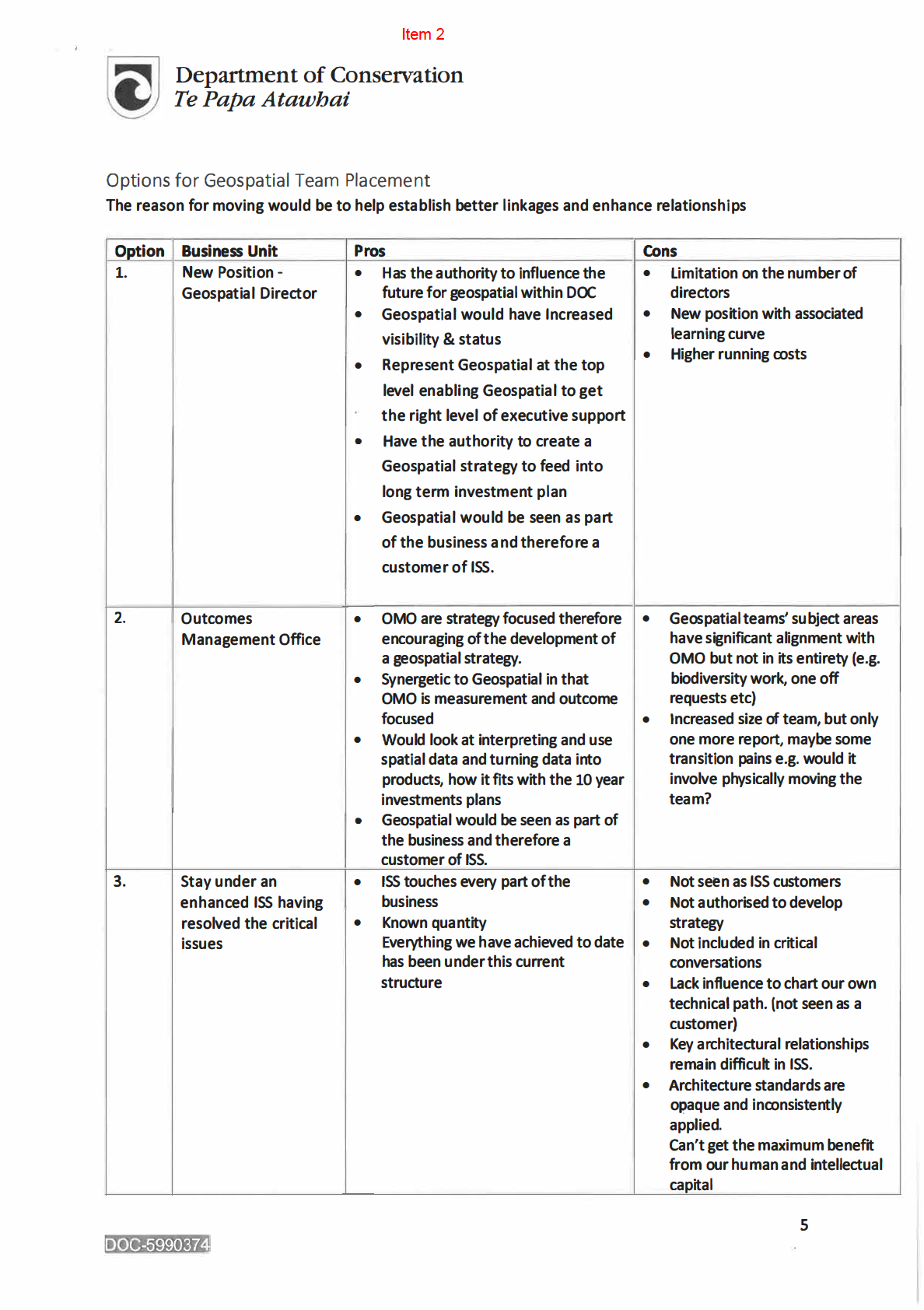
integrated way with the rest of DOC and to be enablers- support other groups and units to achieve
their goals.
Purpose
To determine where GIS bests fits within CSG to provide synergistic returns to DOC.
Quantity
The output of this Task Assignment will be:
Act
• To run a team process, that includes the Business Services Director and the Planning and
Outcomes Director and other key stakeholders from the business to identify the fit within
CSG for the Geospatial Services Team, to provide synergistic return 28 June 2019
• Recommend option to DDG CSG for approval together with costs (if any) 28 June 2019
• Produce a plan 12 July 2019
• Identify SPA for all described work items 12 July 2019
• Provide regular updates on the resulting plan to the Deputy Director-General Corporate
Services during your monthly operating review.
Information
Quality
The resulting plan will clearly identify expected timeframes, dependencies, critical issues, mitigation,
accountability and key success measures.
Official
Resources
the
n/a
Timing
under
Team process and analysis by 28 June 2019
Recommendation/ Proposal to SPA Rose Anne Macleod by 12 July 2019
Released
DOCCM-5963186
Act
Information
Official
the
under
Released

Act
Information
Official
the
under
Released

Act
Information
Official
the
under
Released

Act
Information
Official
the
under
Released

Act
Information
Official
the
under
Released
Act
Information
Official
the
under
Released

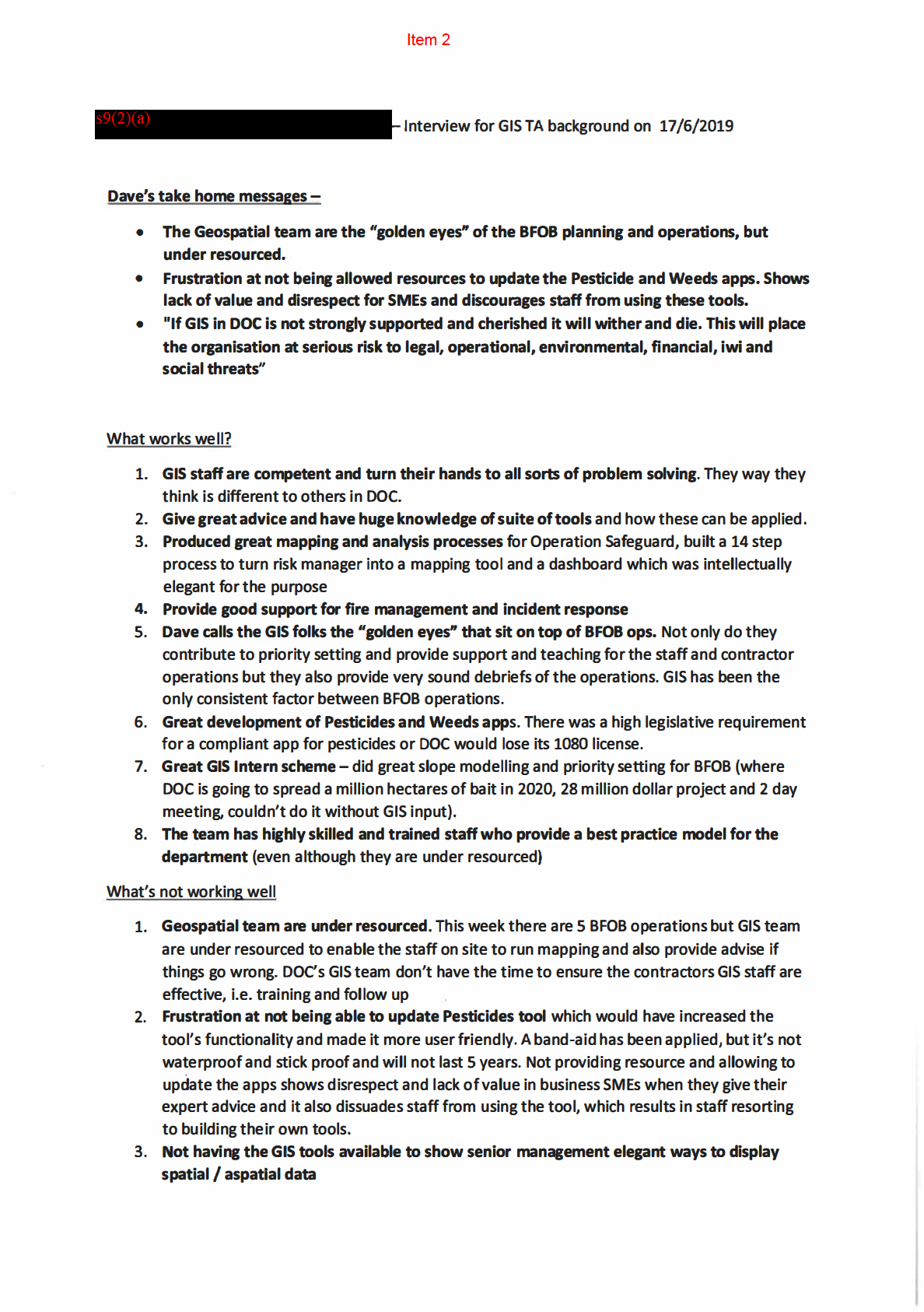
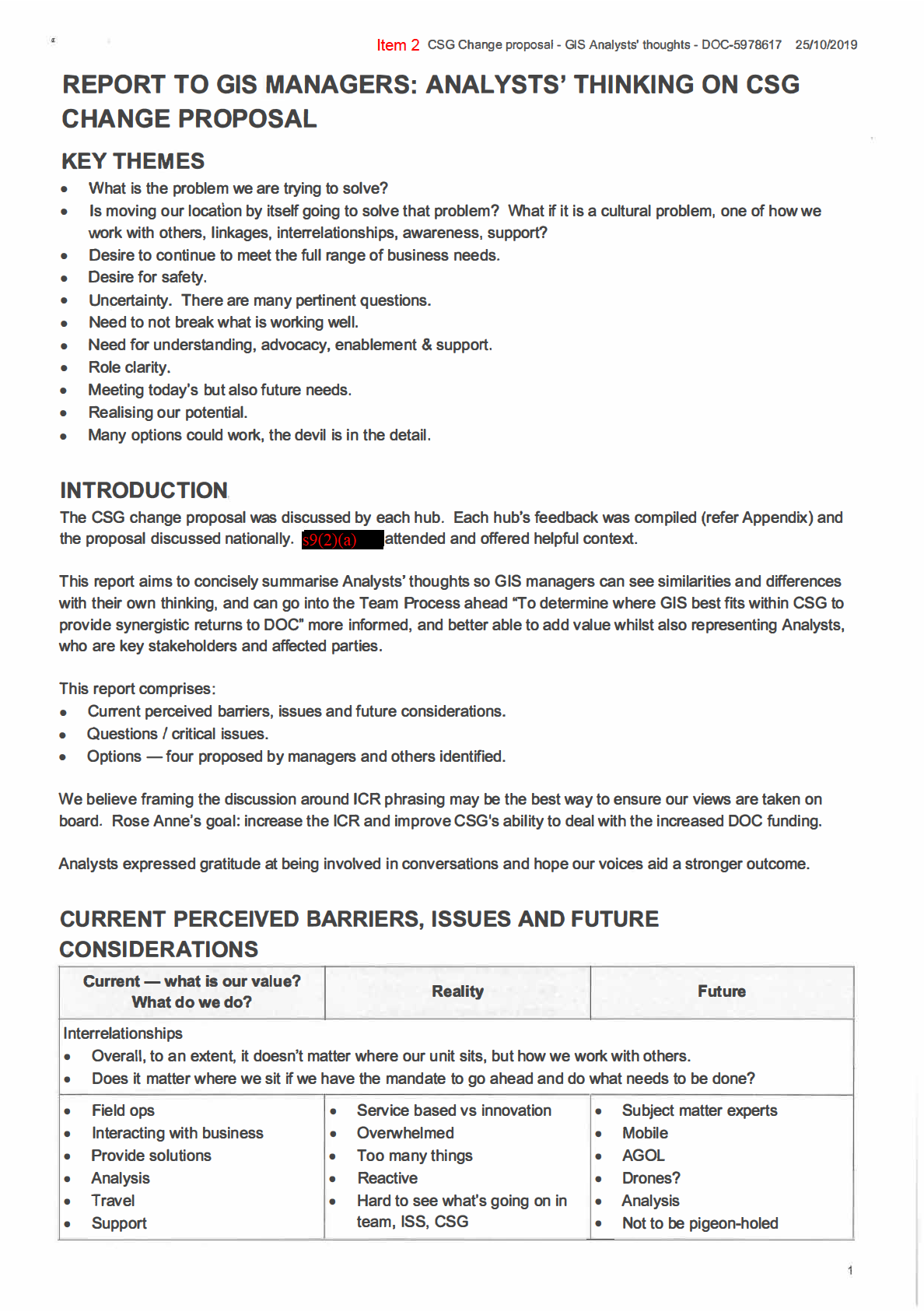
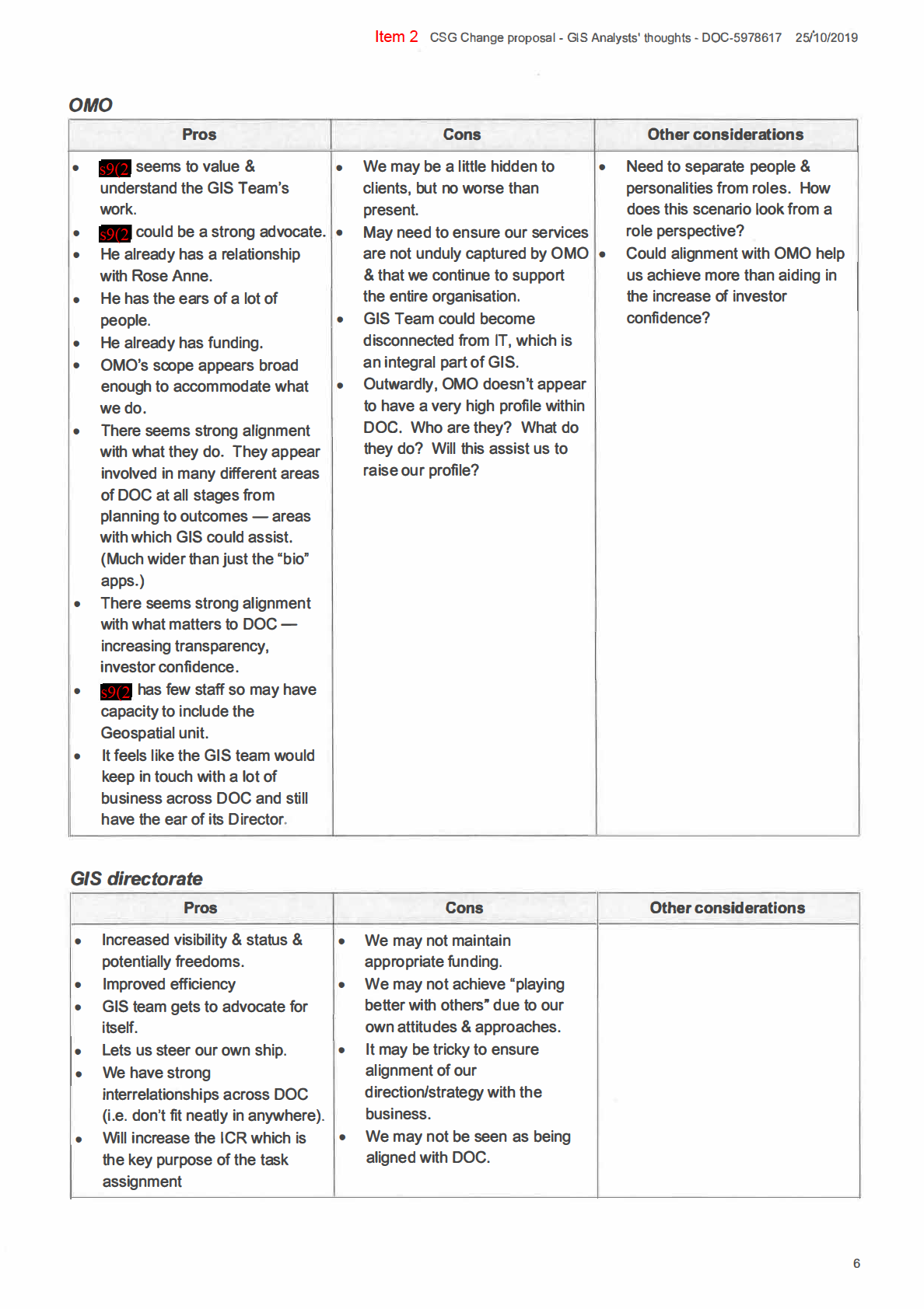
Item 2 CSG Change proposal - GIS Analysts' thoughts - DOC-5978617 25/�0/2019
• Innovation
•
•
Communication - within the
• More Innovation
Data management
•
team, to/from the team - is
• Invited to team process
System integration
anyone listening?
•
•
Advise
Advising
• Roles not clear
•
•
Support
Outside of DOC thought well of
• ProjecUtask creep
•
•
Less map making
Broad remit> hard to fit in a
• We are GIS but no control over • Task assignment environment
single place
data management
•
•
Presence in offices > raise the
Close links with operations
• Current structure under ISS
standard across organisation
• ISS can be a roadblock
• Role clarity
• No strategy
• GIS strategy & road map
• No road map
• Transparency of workloads
• Not a client of ISS
• A clear voice within the
•
Act
Recommendations can get
organisation
ignored
• Functional split within the team
• DOC sees GIS as a solution but • Need to be seen as a customer,
the GIS Team doesn't feel
with a Director accountable for
backed up by it's Directorate.
providing GIS what they require
• Wide scope > clients across
to deliver outcomes .
business
• Mandate from business - go
• Limited by lack of authority
forth and do good stuff for
• Slow progress > 2016 report
conservation, ICR.
recommending should we be in
• We need delivery agreements
Information
planning and outcomes, not
with GIS support structures as
much has happened until now.
we are their customer (there are
• Authority > not recognised as
currently none, leading to GIS
subject matter experts
needing to complain until things
• Team might not feel safe raising
are fixed, just to maintain basic
issues re. things not working in
service delivery).
Official
ISS.
• Director above GIS should have
a real understanding of what
T earn structure
GIS can bring to the business
the
• location not function based .
and be an advocate for it.
• Specialisations not clearly
defined.
• Not enough clarity on roles .
• Expectations - distributed vs
under hub roles.
Communication
• To/from the organisation .
• Too busy to communicate out.
• Can be the last one to know,
called in at last minute to fix
stuff.
Released • Within the team .
• Feeling like no one listens .
• Task management, hard to see
tasks across the team.
2

CSG Change proposal - GIS Analysts' thoughts - DOC-5978617 25/10/2019
Item 2
Data management
• We can't fix data we don't own
but if make suggestions, can't
act on them.
• We are GIS but we have no
control over data management.
QUESTIONS/ CRITICAL ISSUES
Issue
Elements
1. How to understand the
•
What is the problem we are trying to solve? Limited awareness of our unit?
problem & ensure the
Barriers to fulfilling our role? Being left out of conversations? Not being seen
Act
appropriateness of scope
as enablers?
of the proposed
•
What if Mahi Kotahi is about changing the structure yet the issue is a cultural
response?
one?
•
What if the focus should be more about what the GIS Team needs to reach its
full potential rather than where it should sit?
•
Will moving within the organisational structure help resolve the problem?
•
What are the alternatives?
•
!f not a total solution, what other strategies are we able to employ?
•
What can we influence outside the Group?
Information
•
How do we address current ISS pinch points?
•
What changes will moving our location bring about?
•
Are we going to look at the team structure as part of this? What if there is an
opportunity to restructure => optimise change once?
•
Are any peripheral GIS Staff (data architects, database administrators, etc.)
moving & what are the likely implications?
Official
2. What if the integrity of the •
Decision-makers' depth of knowledge of the Geospatial Services Team & its
process reduces outcome
potential.
quality, Analysts' trust &
•
Timeframe is very tight, not the advised "3 months".
the
engagement, & does not
• Integrity & effectiveness of consultation .
bring the rest of DOC on
• Seemingly parallel rather than fully collaborative discussions .
the journey?
• Poor documentation - gaps, ambiguities, nebulous "business speak" .
Options given in the Task Assignment Context may reduce abilities to meet the
Purpose.
under
•
Limited &/or delayed information sharing.
•
PSA's awareness & involvement.
•
Likely limited effectiveness of proposed intranet notices, poor discoverability of
Mahi Kotahi.
•
Poor confidence in this process. Feeding into this - how come GIS wasn't
involved in delivering the 2016 PIF: " ... a priority should be for geospatial
information to make a comprehensive contribution to planning, prioritising and
sharing DOC activities and success .... "
Released
3. What if the role of the
•
Are we Services? Support? Advisors? Leaders? All of these?
Geospatial
Services
•
What does a Centre of Excellence look like? Do?
Team is unclear &
•
Are we Data? Apps? Analysis? Mapping? Cartography? GPS? Drones?
understood differently by
Remote sensing?
different parties?
•
How do we fit into Mahi Kotahi? Do we provide Professional Services across
DOC - should we be included in 2 along with Legal & Administration? What
is our role in developing "future-focused IT tools"?
•
What are our obligations to the business e.g. Service Level Agreements?
•
What can we do to make sure it is understood going forward? We are currently
3
Act
Information
Official
the
under
Released
Act
Information
Official
the
under
Released
Act
Information
Official
the
under
Released

Item 2 CSG Change proposal - GIS Analysts' thoughts - DOC-5978617 25/10/2019
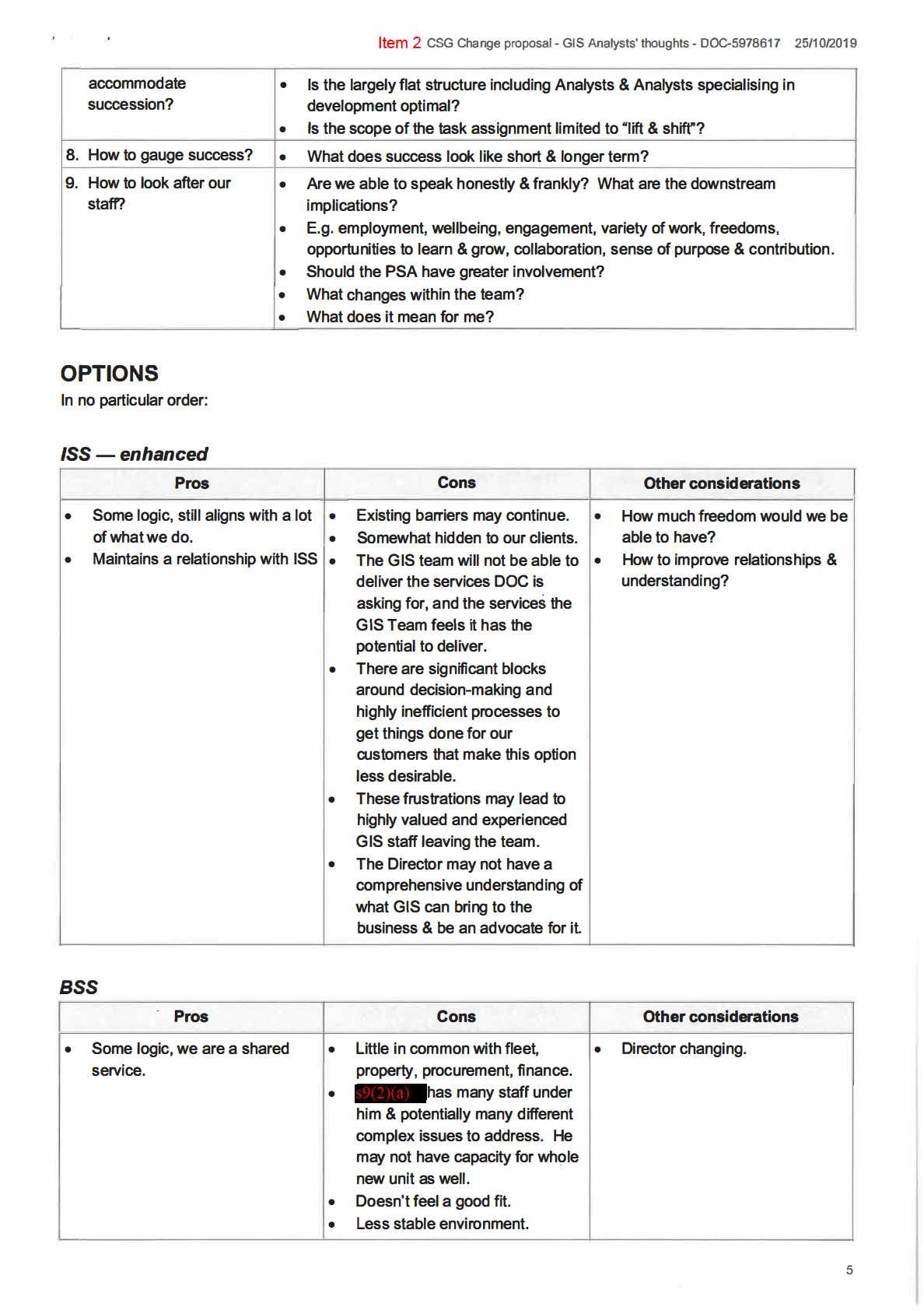
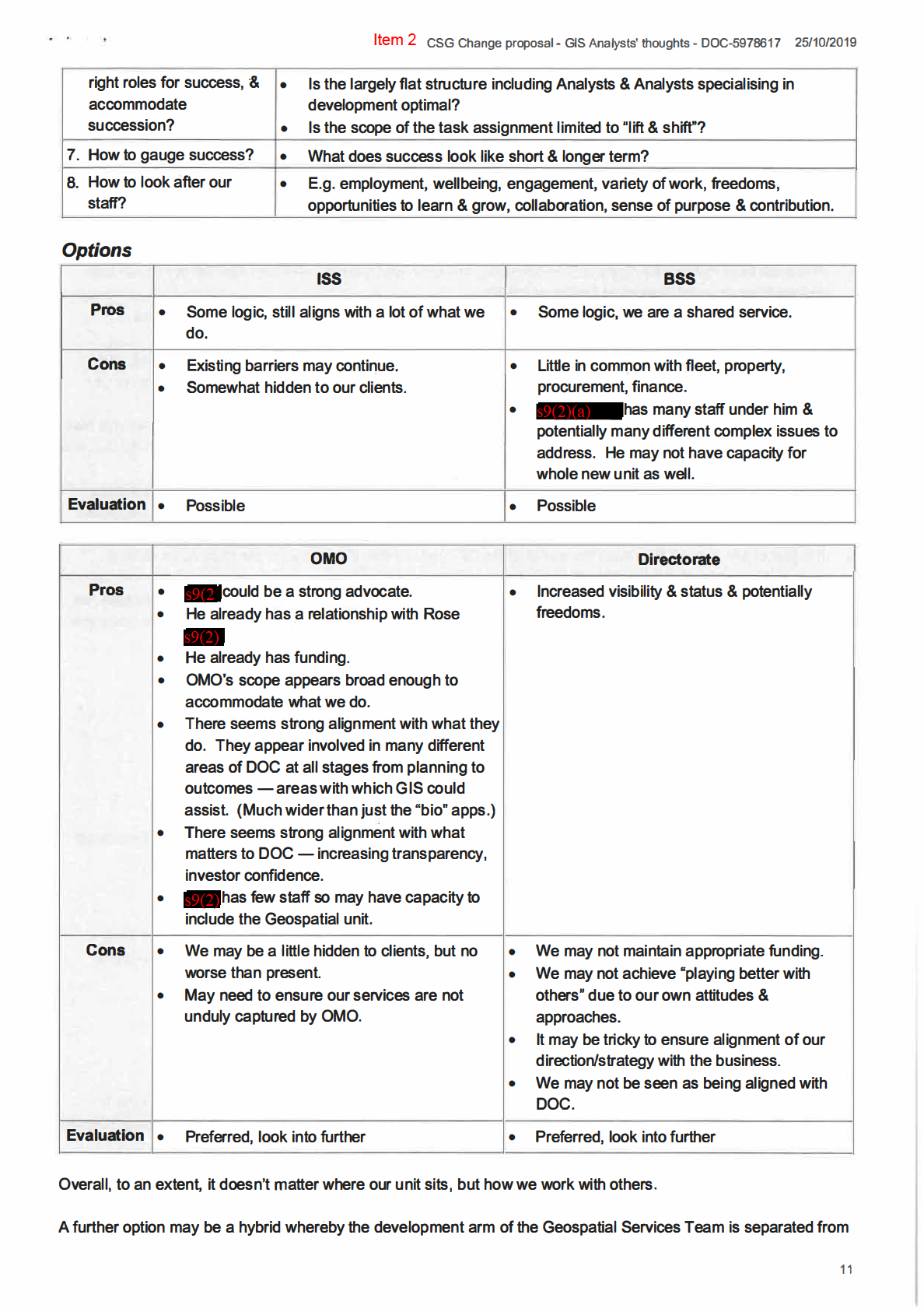
New ISS structure, GIS alongside ISS
A Chief Technical Officer (CTO} and a Chief Information Officer (CIO) sitting alongside each other. GIS could sit
under the CTO (new Director}, focusing on delivering solutions to customers. The rest of ISS could sit under the
CIO, focusing on organisational solutions (IT/Infrastructure/Security/etc ... ). This would have the benefit that IT
would not be too far away from GIS.
Operations I planning
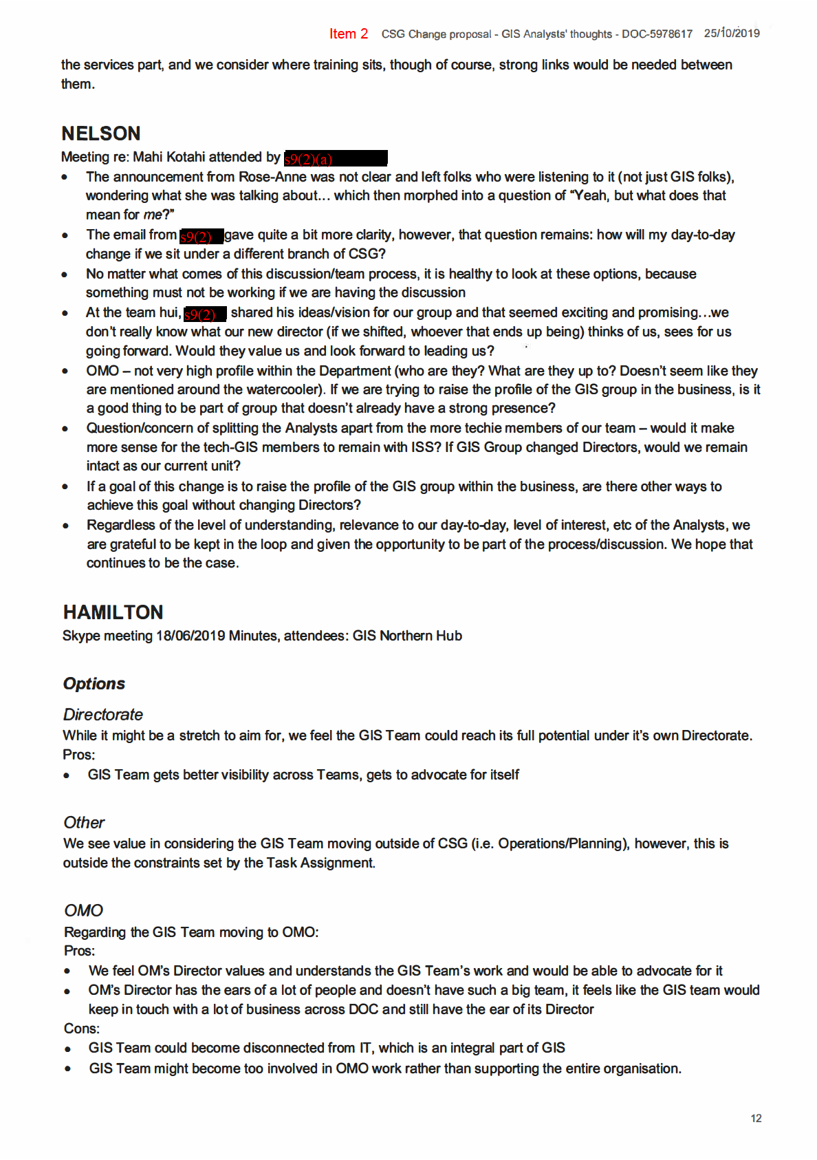
We see value in considering the GIS Team moving outside of CSG (i.e. into Operations/Planning}.
Pros
Cons
Other considerations
• Ops Planning is a great fit to
• Rose Anne's objective is to
stay as one GIS Team
increase ICR and CSG's ability
Act
to deal with DOC's increased
funding.
Information
Official
the
under
Released
7

Item 2 CSG Change proposal - GIS Analysts' thoughts - DOC-5978617 25/1'0/2019
APPENDIX:
HUB REPORTS ON CSG CHANGE PROPOSAL 19-6-19
Hubs held their own meetings on Monday 17 and Tuesday 18 June, these are their summaries ahead of a national
team meeting.
CHRISTCHURCH
Current, reality, future
Current - what is our value?
Reality
Future
• Field ops
•
•
•
Service based > little innovation
Subject matter experts
Interacting with business
•
•
•
Overwhelmed
Mobile
Act
Provide solutions
•
•
•
Too many things
AGOL
Analysis
•
•
•
Reactive
Analysis
Travel
•
•
•
Hard to see what's going on in
Not to be pigeon holed
Support
team, ISS, CSG
•
•
Innovation
Innovation
• Communication - within the
•
•
Invited to team process
Data management
team, to/from the team - is
•
•
Advise
System integration
anyone listening?
•
•
Support
Advising
• Roles not clear
•
•
Less map making
Outside of DOC thought well of
• Project/task creep
•
•
Task assignment environment
We are GIS but no control over
• Presence in offices > raise the
Information
data management
•
standard across organisation
ISS can be a roadblock
•
•
Role clarity
No strategy
•
•
GIS strategy & road map
Not a client of ISS
• Transparency of workloads
• A clear voice within the
organisation
Official • Functional split within the team
the
Critical issues
Current location as part of ISS
•
Not seen as client by ISS
•
Not recognised as part of the business > can't state requirements
•
ISS can be a roadblock> difficult to do project work
under
•
Slow progress> 2016 report recommending should we be in planning and outcomes, not much has happened
until now
•
Recommendations can get ignored
•
Not allowed to make a strategy
Wide scope of work (projects, assyst, technical, operations)
•
We don't really fit anywhere
•
Clients across the business
Released
•
Service based > reactive vs innovation
•
Overwhelmed> too many things> reactive
•
Project task/creep
Team structure
•
Location not functional based
•
Specialisations not clearly defined
•
Not enough clarity on roles
•
Expectations - distributed vs hub roles
8

Item 2 CSG Change proposal - GIS Analysts' thoughts - DOC-5978617 25/10/2019
•
Task management, hard to see tasks across the team
Communication
•
To/from the organisation
•
Too busy to communicate out
•
Can be the last one to know, called in at last minute to fix stuff
•
Within the team
•
Feeling like no one listens
Authority
•
Not recognised as subject matter experts
•
No strategy, road map
Act
Data management
•
We can't fix data we don't own but if make suggestions and can't act on them
•
We are GIS but we have no control over data management
Options
Director
OMO
ISS
BSS
•
The preferred - lets us •
What can OMO
•
Not ideal
•
What can BSS director
steer our own ship
Director do for GIS?
•
Information
•
What can ISS Director
do for GIS?
We don't fit neatly in
•
Would we lose touch
do for GIS?
•
Would we lose touch
anywhere
with operations?
•
•
How much autonomy?
with operations?
Would we lose
•
How much decision
•
Would we lose
innovation?
•
making?
innovation?
What would hamstring •
Will it change
•
How much autonomy?
us?
•
Official
•
anything?
We become a client of
How much autonomy? •
•
How do we address
ISS
We become a client of
current ISS pinch
ISS
points?
the
Uncertainties
•
What changes within the team?
•
What can we influence outside the group?
•
Would we lose touch with operations if moved to another unit?
under
•
What level of freedom/autonomy under another director?
Questions
•
How much freedom or autonomy under another director?
•
How do we quantify our level of freedom?
•
Is it the team or just high level reporting structure that is up for change?
•
How many new roles? Any managers?
Released
•
What are our current Service Level Agreements with the business?
•
What can we do to future proof GIS?
•
Are we going to look at the team structure as part of this? opportunity to restructure > do it once, do it right.
include team structure
•
Can we split the team? Put under separate directors? BAU vs technical vs projects vs support & shared
service
•
What can we do to future proof GIS?
•
If all this fails and we stay as we are - what can we do to make systems work better for everyone?
•
How can we manage our tasks as a team more transparently?
9

Act
Information
Official
the
under
Released
Act
Information
Official
the
under
Released
Act
Information
Official
the
under
Released

. ' .
Item 2 CSG Change proposal - GIS Analysts' thoughts - DOC-5978617 25/10/2019
/SS
Regarding the status quo option/GIS Team remaining under ISS:
Cons:
•
We feel the GIS team will not be able to deliver the services DOC is asking for, and the services the GIS Team
feels it has the potential to deliver
•
There are significant blocks around decision-making and highly inefficient processes to get things done for our
customers that make this option non-desirable
•
These frustrations may lead to highly valued and experienced GIS staff leaving the team
BSS
Regarding GIS moving to BSS:
Cons:
Act
•
We feel this would not be a good fit; less stable environment
Discussion points regarding issues GIS Team Is experiencing
•
Constraints regarding tools/software the team can/can't use, leading potentially to work being contracted out
•
How to get influence across teams/get more visibility? How to ensure GIS Team is involved at initial project
meetings/team process meetings/etc ... ?
•
What if GIS Team moves out of ISS, how would ISS address it's IT challenges at the coal front? Someone
strong· enough would have to ensure IT Services are still provided to customers
•
Information
GIS needs to be seen as a customer, with a Director accountable for providing GIS what they require to deliver
outcomes
•
How to find appropriate Business Owners for the projects handled by GIS Team. Steps are being taken, but
this is still a pain point.
•
Mahi Kotahi is changing the structure while it seems the issues seems to be a cultural one
o This exercise should be more about what the GIS Team needs to reach its full potential rather than
where it should sit.
Official
o DOC sees GIS as a solution but the GIS Team doesn't feel backed up by it's Directorate.
o Director above GIS should have a real understanding of what GIS can bring to the business and be an
advocate for it - This is a most important statement for the GIS Team
the
o What if the point above can't be spoken out safely by the GIS Team?
o Regarding the point above, should PSA be involved?
•
A suggestion was raised that a Director sits above both a Chief Technical Officer (CTO) and a Chief
Information Officer (CIO). GIS could sit under the CTO, focusing on delivering solutions to customers. The rest
of ISS could sit under the CIO, focusing on organisational solutions (IT/Infrastructure/Security/etc ... ). This
under
would have the benefit that IT would not be too far away from GIS
•
Are any peripheral GIS Staff (data architects, database administrators, etc) moving?
•
We need delivery agreements with GIS support structures as we are their customer (there are currently none,
leading to GIS needing to complain until things are fixed, just to maintain basic service delivery).
Released
13

Act
Information
Official
the
under
Released
Act
Information
Official
the
under
Released

Act
Information
Official
the
under
Released

Act
Information
Official
the
under
Released
Act
Information
Official
the
under
Released

Item 2
Department of Conservation
Te Papa Atawhai
�
4.
Business Shared
• Both BSS and Geospatial involved in • Geospatial team's subject areas
Services
every part of the business.
have little alignment with BSS
• Functionally aligned.
• Current Director doesn't know
• Geospatial would be seen as part of
GIS, would take time to come up
the business and therefore a
to speed.
customer of ISS.
• Strategy is something they do by
default.
5.
Outside CSG i.e.
• 80% of GIS work is from OPS. A
• Already tried and failed to get
Operations
logical fit considering the
business ownership through
Act
importance of spatial in planning
operations.
process
• OPS focus is delivery, not
• Geospatial would be seen as part of
strategic
the business and therefore a
• Would challenge the operating
customer of ISS.
model that's been put in place.
• Geospatial teams subject areas
have significant alignment with
Operations but not in its entirety
(e.g. biodiversity work, one off
requests etc)
Information
Recommendations
Official
Recommended Options
1. Own Geospatial Director - Reporting to DOG Corporate Services
the
• Would give the Geospatial unit Increased visibility and the status to future enable geospatial
within DOC
• Ability to represent Geospatial to get the right level of executive support
• Give the Geospatial unit the mandate to build a strategy to feed into the long-term investment
under
plan and the influence to execute it.
2. Move under the Planning and Outcomes unit (Outcomes Management Office - OMO)
• Would give Geospatial the opportunity to build a strategy that aligns with the reporting
needs of the organisation, better addressing the issues identified in the KPMG 2018 report.
• The current OMO director already understands the power of spatial and the reporting needs
of the organisation leading to a synergistic relationship for DOC.
Released
Costs
To be scoped
i•i•ii&i@ucfZI
Act
Information
Official
the
under
Released
Act
Information
Official
the
under
Released

Act
Information
Official
the
under
Released

Item 2
Neal Gordon
From:
Lou Sanson
Sent:
Thursday, 29 August 2019 10:07 a.m.
To:
Neal Gordon
Cc:
Rose Anne Macleod
Subject:
Fwd: GIS Realignment to Neal Gordon
Good to go unless budget implications
Act
Sent from my Samsung Galaxy smartphone.
------- Original message ---
From: Suzanne Edwards <[email address]>
Date: 28/08/19·11:13 AM (GMT+12:00)
To: Lou Sanson <[email address]>
Cc: Karen Jones <[email address]>
Subject: RE: GIS Realignment to Neal Gordon
Information
Hi Lou
I have no concerns about the Geospacial Services Team being moved to the Outcomes Management Office as this is
a discrete action.
Official
Regards
Suzanne
A/DD-G, People and Engagement
the
PS. I would like to talk to you about the Admin/Operations Support work ....
From: Lou Sanson <[email address]>
Sent: Wednesday, 28 August 2019 9:06 AM
under
To: Suzanne Edwards <[email address]>
Cc: Karen Jones <[email address]>
Subject: GIS Realignment to Neal Gordon
Hi Suzanne
Rose Anne wants this signed today.
All OK from HR/OD?
Lou Released
Sent from my Samsung Galaxy smartphone.
1
Act
Information
Official
the
under
Released